



The Canary Islands Government has declared a maximum wind alert for La Palma and the mountainous areas of Tenerife as Storm Charles approaches the archipelago, bringing potentially destructive gusts of up to 140 kilometres per hour.
The highest alert level will come into effect at midnight on Wednesday, 11 November, coinciding with the period when the storm is forecast to reach its greatest intensity.
Meanwhile, the rest of Tenerife, together with El Hierro, La Gomera, Gran Canaria, Fuerteventura and Lanzarote, will remain under a wind alert that came into force at 6.00 pm on Tuesday, 10 November.
The decision was announced by the Canary Islands Government’s Directorate-General for Emergencies following an assessment of forecasts issued by Spain’s State Meteorological Agency (Aemet) and other meteorological sources. The measures have been adopted under the Canary Islands’ Specific Emergency Plan for Risks from Adverse Meteorological Phenomena (PEFMA).
According to the emergency authorities, Storm Charles will generate strong to very strong south-westerly winds, which are expected to intensify throughout Tuesday evening before reaching their peak during the early hours of Wednesday.
Officials have warned that the period from late Tuesday night through Wednesday morning will be particularly critical, especially in mountainous areas, exposed ridges and coastal locations where the terrain could further increase wind speeds.
Although conditions are expected to improve gradually as Wednesday progresses, the authorities stress that the timing will vary between islands and that alert levels will remain under review as the storm develops.
La Palma faces gusts of up to 140 km/h
La Palma is expected to experience some of the most severe conditions associated with Storm Charles, with the eastern and northern parts of the island particularly exposed.
Forecasts from the Directorate-General for Emergencies indicate that wind gusts could reach 140 km/h across the eastern and northern half of La Palma, while exposed locations on the western side could experience gusts of up to 120 km/h.
The combination of powerful south-westerly winds and the island’s mountainous terrain is expected to create particularly challenging conditions along ridges, elevated roads and other exposed areas.
The strongest winds are forecast during the early hours of Wednesday, continuing into the morning. The authorities expect the situation to begin improving from approximately 9.00 am, although occasional severe gusts may persist in exposed locations.
Emergency officials are advising residents to secure outdoor furniture, flowerpots and other loose objects that could become dangerous in strong winds.
Particular caution is recommended when travelling through mountainous areas or on roads exposed to crosswinds, where sudden gusts may affect vehicle stability.
Tenerife: mountain peaks could see winds exceeding 130 km/h

In Tenerife, the maximum alert will be concentrated in the island’s highest areas, particularly Teide National Park and the Corona Forestal, where wind gusts are forecast to reach approximately 136 km/h.
These areas are expected to bear the brunt of the storm because of their altitude and exposure to the strong south-westerly airflow.
The north-western ridge of Tenerife is also expected to experience exceptionally strong winds, with gusts generally reaching 120 km/h and potentially exceeding 130 km/h in the most exposed locations.
Elsewhere on the island, the eastern, southern and western slopes could experience maximum gusts of around 110 km/h, with the south-east identified as one of the areas particularly vulnerable to the storm.
The Directorate-General for Emergencies has warned that gusts exceeding 120 km/h could continue in Tenerife’s mountainous areas until approximately 1.00 pm on Wednesday, 11 November.
This means the island’s highest elevations may remain exposed to hazardous conditions for several hours after the storm begins to weaken elsewhere.
The authorities are urging people to avoid unnecessary journeys into mountainous areas, particularly around Teide and along exposed forest roads, while the strongest winds persist.
Falling branches, dislodged objects and sudden crosswinds are among the potential hazards during periods of severe weather.
Aemet issues significant wind warnings across the Canary Islands
Alongside the maximum alert declared by the Canary Islands Government, Aemet has issued its own wind warnings for several parts of the archipelago.
These warnings identify areas where the storm could produce particularly strong gusts and establish the periods during which the greatest danger is expected.
According to the warnings issued for Storm Charles, the forecast maximum gusts and warning periods are:
| Island or area | Maximum gusts | Warning period |
|---|---|---|
| La Palma: peaks, east and west | 110 km/h | Tuesday 6.00 pm – Wednesday 3.00 am |
| Tenerife: north | 120 km/h | Tuesday 9.00 pm – Wednesday 2.00 pm |
| Tenerife: east, south and west | 110 km/h | Tuesday 9.00 pm – Wednesday 2.00 pm |
| La Gomera | 100 km/h | Tuesday 9.00 pm – Wednesday 6.00 pm |
| El Hierro | 100 km/h | Tuesday 9.00 pm – Wednesday 6.00 pm |
These figures refer specifically to Aemet’s forecast wind gusts within its warning system. The Canary Islands Government’s emergency forecasts indicate that locally stronger gusts may occur, particularly in the most exposed areas of Tenerife and La Palma.
On La Gomera, south-westerly winds are expected to affect mountainous and mid-altitude areas, as well as exposed stretches of the northern, north-western, southern and south-eastern coastline.
On El Hierro, the highest elevations and coastal areas at the island’s eastern and western extremes are expected to experience some of the strongest winds, with gusts potentially reaching 100 km/h.
Although the most extreme conditions are forecast for La Palma and Tenerife’s mountain peaks, the authorities have emphasised that severe gusts could occur across several islands.
Coastal alert as Storm Charles brings waves of up to four metres
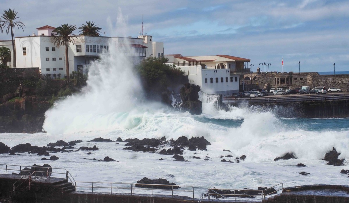
In addition to the wind alerts, the Canary Islands Government has updated its coastal weather warning for the entire archipelago, effective from 6.00 pm on Tuesday, 10 November.
The Directorate-General for Emergencies expects sea conditions to deteriorate significantly as Storm Charles approaches, with combined wave heights of between three and four metres, rough to very rough seas and a north-westerly swell.
The storm will also bring south-westerly winds reaching force seven on the Beaufort scale, equivalent to speeds of approximately 50 to 61 km/h.
The combination of strong winds, high waves and swell is expected to create dangerous conditions along exposed coastlines, particularly where waves can break against promenades, harbour walls and rocky shores.
The areas considered most vulnerable include the northern, north-western and western coasts of the islands.
Particular attention is being paid to La Palma, El Hierro and La Gomera, as well as Tenerife’s northern coastline and the western shores of Lanzarote and Fuerteventura.
In Gran Canaria, emergency officials are highlighting the north, north-west, west and south coasts, especially locations directly exposed to the south-westerly winds and incoming swell.
The authorities are also recommending extreme caution around ports, quays and south-west-facing coastal areas, where wind conditions could further aggravate the state of the sea.
Residents and visitors are being urged to avoid breakwaters, coastal platforms and other exposed locations where unexpected waves could sweep people into the water.
High tides could increase coastal risks
Storm Charles is also expected to coincide with relatively high tidal coefficients, potentially increasing the impact of large waves in vulnerable coastal areas.
The forecast tidal coefficients are:
- Tuesday, 10 November: 77
- Wednesday, 11 November: 71
- Thursday, 12 November: 64
- Friday, 13 November: 55
The higher coefficients at the beginning of the storm indicate a greater tidal range, which could contribute to more hazardous conditions when combined with strong winds and heavy swell.
On Wednesday, 11 November, high tides are expected at approximately 1.40 am to 2.05 am, depending on the location, with a second high tide forecast between 2.00 pm and 2.25 pm.
The early-morning high tide is of particular concern because it coincides with the period when Storm Charles is expected to produce its strongest winds.
Emergency officials are therefore advising people to stay away from exposed coastal areas, especially during high tide, and to avoid approaching the sea to photograph or observe large waves.
When will Storm Charles be at its worst?

The most dangerous period associated with Storm Charles is expected to begin late on Tuesday, 10 November, as south-westerly winds strengthen across the archipelago.
Conditions are forecast to deteriorate further overnight, with the early hours of Wednesday, 11 November, expected to bring the storm’s peak intensity.
On La Palma, the strongest gusts are expected overnight and during the early morning, with winds forecast to begin easing from around 9.00 am.
In Tenerife, the situation could remain hazardous for longer, particularly in the mountainous areas around Teide and the Corona Forestal, where gusts exceeding 120 km/h may persist until approximately 1.00 pm.
Other islands, including La Gomera and El Hierro, could continue to experience strong winds into Wednesday afternoon, according to the warning periods established by Aemet.
Although the storm is forecast to weaken gradually, the authorities caution that improvements may not occur simultaneously across the archipelago.
Local conditions will depend on factors such as altitude, exposure to prevailing winds and the interaction between the storm and the islands’ mountainous terrain.
Emergency recommendations: how to stay safe during Storm Charles
With exceptionally strong winds and hazardous sea conditions forecast, the Directorate-General for Emergencies is urging residents and visitors to take precautions throughout the affected period.
People are advised to secure or remove loose objects from balconies, terraces, gardens and rooftops, including outdoor furniture, flowerpots, decorations and other items that could be blown away.
The authorities also recommend avoiding unnecessary outdoor activities in mountainous or exposed areas, particularly where strong gusts could make walking or driving dangerous.
Extra care should be taken on the roads, especially when travelling through elevated areas or along routes exposed to crosswinds. Drivers should be alert to falling branches, debris and sudden changes in wind strength.
Residents are also advised to keep their distance from trees, walls, scaffolding, advertising structures and other objects that could become unstable during severe gusts.
Along the coast, people should avoid breakwaters, quays, rocky shorelines and other areas exposed to large waves.
The authorities stress the importance of following official weather warnings and emergency advice, particularly as conditions may change rapidly during the storm.
Authorities continue to monitor the storm

The Canary Islands Government’s Directorate-General for Emergencies is maintaining close surveillance of Storm Charles as it approaches the archipelago.
The evolution of the weather system, together with updated forecasts from Aemet and other meteorological services, will determine whether the current alert levels need to be extended, modified or lifted.
For the time being, La Palma and Tenerife’s mountainous areas remain the principal areas of concern, with gusts potentially reaching 140 km/h and 136 km/h respectively.
Strong winds, dangerous coastal conditions and waves of up to four metres are also expected to affect other parts of the Canary Islands.
Residents and visitors are encouraged to monitor official updates and exercise particular caution from Tuesday evening until weather conditions begin to improve on Wednesday.
The most critical period is expected overnight, making it especially important to take preventive measures before the strongest winds arrive.